14060 | |

Roth Park - 12km

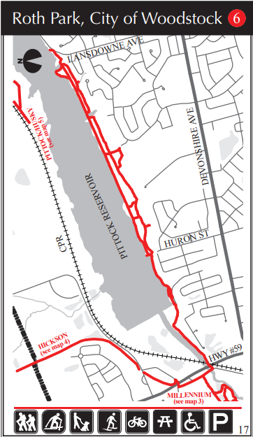
Roth Park is on the south side of Pittock Lake. There are picnic facilities and is home to the Woodstock Rotary Dragon Boat.

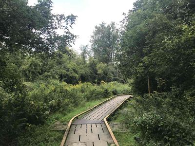
The trail is wide with hard-packed dirt and granular and provides a lovely view over the lake. There are also side trails, which branch through a pine plantation and go up and down some gentle inclines. These side trails link back to the main trail. At Lansdowne Ave.

The trail going west from Huron Street goes by the dam and then along the Thames River. A new section of trail has been completed that allows the hiker to go under the railway bridge and Hwy # 59 and arrive at Tecumseh St. Across the street is the entrance to the Millennium Trail System.

Length: 12 km (linear)

Difficulty: Easy

Facilities: Parking, picnic tables, washrooms (summer seasonal)

Trail Uses: Hiking, cycling, birding

Primary Surface: Mixed (gravel, natural, paved)

Location: South side of Pittock Lake; take Huron St. N. to the end, turn right and drive to the parking lot

Open: All year


How can I help keep Oxford County beautiful and healthy?

Bring along your favourite reusable water bottle. Leave all places in a better state than when you arrived. Give wildlife space; even if animals do not run away from you, they may be protecting young. Provide adequate space for flora and fauna. Take in the changing terrain, stay on the path and avoid them during wet/muddy periods. If the parking lot is full at the trail you're visiting, consider coming back at a different time or choosing a different trail to avoid overuse. Finally, take only photos and leave only footprints. If you'd like to give back, you can consider purchasing a tree.

What other trails are nearby? What trails are over 5km?

Nearby trails in and around Woodstock include the Millenium Trail System, Hickson Trail, Sliver Trail and the Herbert Milnes Trail. If you’re looking for a trail 5km or over, we have: Wildwood Trail (25km), Avon Trail (19km), Millenium Trail System (6km), Hickson Trail (9km), Sliver Trail (5.25km), The Carroll Trail (5km) or the Trans-Canada Trail (17km). To learn more about these trails, check out our Trails and Hiking Page .

How far is this trail system from downtown Woodstock?

Not too far at all. It’s about a 5-minute drive from the main access point.

Where can I grab a bite nearby?

Check out our blog post on A Food Lover’s Guide to Woodstock.

Contact Information

Upper Thames River Conservation Authority
519-539-5088

Map

Pittock Conservation Area
Enjoy camping, hiking, birding, paddling, fishing and recreation programs. Many children's activities are...
Millennium Trail System - 6km or less
 The Millennium Trail System includes trails developed by the City of Woodstock, Woodstock Rotary Club,...
Hickson Trail - 10km
This beautiful trail runs along an old railway bed from Woodstock,  north through 9 km of Oxford County...

Trip Ideas

7 Must Trek Hikes Through Oxford
Lucky for us, Oxford County is located in the heart of Ontario's lush Carolinian Life Zone which means...
7 Oxford Trails to Get You Outside this Winter
7 Oxford Trails to Enjoy in Winter Fresh air, brisk temps and time in Mother Nature make winter so much...
Hikes & Hamburgers: Match up your next great hike with a hearty meal in Oxford County
1. The Trans Canada Trail + The Indigo Lounge For the hike: Tillson Ave, Tillsonburg ON (just south...
3 Hiking Trails in Southern Ontario: Get off the beaten path in Oxford County
Where Should I Hike? So...you want to get outdoors, eh? If you're looking for a quiet hiking trail in...